Acquiring coastal land and beachfront property in Ilocos Sur offers exceptional lifestyle prestige and high-yield commercial potential, from boutique eco-resorts in Santiago Cove and San Esteban to private seaside estates along the rolling shores of Cabugao and Sinait. However, navigating the Philippine coastal property market requires rigorous maritime legal knowledge and forensic due diligence. In the Philippines, private land ownership stops strictly at the high-tide mark, while statutory environmental easements and state-owned foreshores govern the waterfront. This definitive practitioner guide outlines the legal statutes, DENR foreshore leasing protocols, tidal boundary surveys, and environmental due diligence required to secure, develop, and protect prime coastal property across Ilocos Sur.
Quick Answer: What Legal Rules and Environmental Easements Govern Buying Beachfront Property in Ilocos Sur?
If you are evaluating the purchase or commercial development of coastal and beachfront property in Ilocos Sur, these core legal doctrines and statutory mandates govern your transaction:
- Private Titles Stop at the High-Tide Mark: Under the Regalian Doctrine and Commonwealth Act No. 141 (The Public Land Act), beaches, shores, and foreshore lands belong to the public domain and are non-alienable. Even if an older Torrens title or tax declaration purports to cover land down to the low-water mark, the portion below the Mean High-Water Mark (MHWM) is legally void ab initio. Private ownership can only apply to titled upland land situated inland from the high-tide line.
- Mandatory Water Code Setbacks (Article 51, PD 1067): Presidential Decree No. 1067 (The Water Code of the Philippines) enforces strict public easements measured inland from the high-tide mark: 3 meters in urban areas, 20 meters in agricultural and rural zones, and 40 meters in forest or timberland areas. This zone is reserved for public salvage, recreation, navigation, and environmental protection. You cannot build permanent residential or commercial structures, concrete boundary walls, or security gates inside this easement.
- Beachfront Utilization Requires a DENR Foreshore Lease Agreement (FLA): If you wish to build commercial resort cabanas, boardwalks, docking pavilions, or retain exclusive commercial access over the beach strip fronting your property, you must secure a 25-year Foreshore Lease Agreement (renewable for another 25 years) from the Department of Environment and Natural Resources (DENR). Riparian and littoral owners of the adjoining titled upland enjoy a preferential statutory right to apply for an FLA over the adjacent foreshore.
- Jurisdiction of CENRO and PENRO in Ilocos Sur: Coastal applications, environmental clearances, and foreshore lease dockets are processed locally through two Community Environment and Natural Resources Offices: CENRO Bantay (supervising northern coastal towns from Sinait and Cabugao to Caoayan) and CENRO Tagudin (supervising southern coastal towns from Santa and Narvacan down to Tagudin), under the appellate supervision of PENRO Ilocos Sur in Vigan City.
- Rigorous Environmental and Geohazard Audits: Coastal properties in Ilocos Sur face direct exposure to the West Philippine Sea. Due diligence requires checking Mines and Geosciences Bureau (MGB) and PAGASA storm surge vulnerability maps, evaluating historical shoreline erosion rates, testing groundwater for saltwater intrusion, and confirming legal right-of-way (ROW) access connecting the parcel to the MacArthur National Highway.
Whether you are planning a beachfront private residence or a commercial resort venture, professional guidance is essential to avoid boundary disputes, regulatory demolition orders, and clouded titles. Browse our verified Ilocos Sur Property Listings or engage our specialized Land Acquisition and Property Due Diligence Services for licensed local representation.
The Coastal Legal Framework: The Water Code (PD 1067), Public Land Act (CA 141), and DENR Foreshore Regulations
Purchasing coastal property in the Philippines differs fundamentally from buying standard urban or agricultural land. While an inland residential subdivision or agricultural farm relies primarily on standard Torrens title conveyance and Registry of Deeds registration, coastal property is governed by a tripartite body of national maritime and environmental legislation designed to preserve public access to the sea and protect fragile coastal ecosystems.
1. Presidential Decree No. 1067 (The Water Code of the Philippines)
Promulgated on December 31, 1976, Presidential Decree No. 1067 governs the ownership, appropriation, utilization, exploitation, development, conservation, and protection of all water resources across the Philippines. For coastal property buyers, the most critical statutory provision is Article 51, which establishes mandatory public easements along the banks of rivers and streams and the shores of the seas and lakes throughout their entire length.
Article 51 strictly classifies these easements based on the surrounding land classification:
- Urban Zones (3-Meter Easement): In designated urban centers, a strip of three meters along the margin of the sea is reserved for public use.
- Agricultural and Rural Zones (20-Meter Easement): In agricultural and rural coastal areas (which comprise the vast majority of coastal strips in Ilocos Sur, including Cabugao, San Esteban, Santiago, and Santa Cruz), a mandatory strip of twenty meters measured landward from the high-tide line is dedicated to public use.
- Forest Zones (40-Meter Easement): Along coastal strips classified as timberland or forest reserve, the statutory easement widens to forty meters.
The statute explicitly mandates that no person shall be allowed to stay in this zone longer than what is necessary for recreation, navigation, floatage, fishing, or salvage, and no permanent structure or improvement of any kind may be erected within this easement strip. Erecting unauthorized concrete fences, retaining seawalls, or buildings inside this easement constitutes an administrative violation punishable by municipal demolition orders and criminal prosecution.
2. Commonwealth Act No. 141 (The Public Land Act)
Enacted on November 7, 1936, Commonwealth Act No. 141 forms the bedrock of public land administration in the Philippines. Under Sections 58 to 68 of CA 141, the law governs the disposition of lands of the public domain suitable for residential, commercial, industrial, or other non-agricultural purposes.
Key legal principles under CA 141 governing coastal properties include:
- Inalienability of the Foreshore: Section 59 explicitly establishes that foreshore lands, the shore, and reclaimed lands cannot be alienated or sold into private ownership. They remain permanently part of the public domain.
- Exclusive Tenurial Mechanism Through Lease: Because foreshore land cannot be purchased or titled, the only legal mechanism to obtain temporary exclusive possession or commercial utilization is through a long-term public lease executed with the national government through the Department of Environment and Natural Resources (DENR).
- The Regalian Doctrine (Jura Regalia): Reaffirmed under Article XII, Section 2 of the 1987 Philippine Constitution, all lands of the public domain, waters, minerals, and other natural resources are owned by the State. Private titles can only be lawfully issued over lands declared alienable and disposable (A and D) by executive proclamation. Foreshores and marine waters can never be classified as alienable and disposable.
3. DENR Administrative Order (DAO) No. 2004-24
To streamline the processing and administration of coastal leases, the DENR issued Administrative Order No. 2004-24, entitled Revised Regulations and Guidelines on the Lease of Foreshore Lands and Miscellaneous Public Lands. DAO 2004-24 outlines the exact procedural roadmap, eligibility criteria, appraisal parameters, lease rental computation formulas, and compliance bonds governing Foreshore Lease Agreements (FLA), Miscellaneous Lease Agreements (MLA), and Foreshore Lease Applications.
Under DAO 2004-24, foreshore lease contracts are granted for an initial term of twenty-five (25) years, renewable for an additional twenty-five (25) years, providing a total potential tenure of up to fifty (50) years. This operational framework allows commercial resort operators, private marina developers, and coastal homeowners to install approved, non-permanent recreational amenities and coastal protections while maintaining regulatory compliance.
4. Supreme Court Jurisprudence on Coastal Land Titles
A recurring hazard in the Philippine coastal property market is the existence of older paper titles or tax declarations that purport to include the beach or foreshore. The Supreme Court of the Philippines has repeatedly ruled that any certificate of title issued over foreshore land or public salvage zones is void ab initio (void from the very beginning).
In landmark decisions including Republic vs. Court of Appeals and Cosalan, Chavez vs. Public Estates Authority, and Republic vs. Court of Appeals and Alpuerto, the high court established that:
- The Torrens system was never intended to shield fraud or grant ownership over properties of the public dominion.
- The State cannot be estopped by the mistake or oversight of its administrative officials. If an old land patent or cadastral survey inadvertently enclosed part of the seashore, the title is invalid to the extent of that coastal encroachment.
- Open, continuous, exclusive, and notorious possession, no matter how long continued, can never ripen into private ownership over foreshore lands, salvage zones, or marine shores.
For a prospective buyer, this jurisprudence means you must never accept a seller assertion that they own the beach simply because an old boundary line touches the water on a sketch plan. Only an independent, on-the-ground geodetic survey can establish legal title limits.
Titled Land vs Foreshore Lease: Understanding Boundaries, High-Tide Marks, and Salvage Zones
To safely purchase and develop coastal property, a buyer must conceptualize the shoreline not as a single property boundary, but as four distinct legal and physical zones moving landward from the ocean. Understanding these zones prevents expensive boundary disputes, building permit rejections, and environmental citations.
The Four Coastal Zones from Sea to Upland
- Marine Offshore Waters (Submerged Zone): The marine bed below the Mean Low-Water Mark. This territory belongs to the sovereign public domain under the jurisdiction of the national government, monitored by the Philippine Coast Guard and the Bureau of Fisheries and Aquatic Resources (BFAR). No private ownership or standard commercial leasing applies here.
- The Foreshore Zone: The intertidal strip of land along the coast between the Mean High-Water Mark (MHWM) and the Mean Low-Water Mark (MLWM), alternately covered and uncovered by the daily ebb and flow of ordinary tides. This land is strictly public domain, but may be legally utilized under an approved DENR Foreshore Lease Agreement (FLA).
- The Salvage Zone / Environmental Easement: The strip of land extending 20 meters inland from the Mean High-Water Mark in rural and agricultural areas (or 3 meters in urban zones, 40 meters in forest reserves). This land may physically fall within the outer perimeter of a private titled parcel, but the owner property rights are permanently encumbered by a statutory public easement under Article 51 of PD 1067. The owner cannot construct permanent buildings, concrete privacy walls, or guard posts within this 20-meter strip.
- Titled Coastal Upland: The private parcel situated completely landward of the Mean High-Water Mark and clear of the statutory public easement. This land can be freely bought, sold, mortgaged, titled under a Transfer Certificate of Title (TCT) or Original Certificate of Title (OCT), and built upon in accordance with municipal zoning and the National Building Code.
The Critical Role of the Mean High-Water Mark (MHWM)
The entire legal architecture of coastal property hinges on a single physical line: the Mean High-Water Mark (MHWM). The MHWM is defined as the average height reached by the surface of the sea at high water over an extended tidal cycle (typically a 19-year National Oceanic and Atmospheric Administration / NAMRIA meteorological tidal observation period).
Because sea levels fluctuate daily, an untrained buyer cannot simply walk onto the beach at 2:00 PM and decide where the property begins. A licensed geodetic engineer must be engaged to conduct a formal boundary relocation and tidal survey. The geodetic engineer accesses official tidal benchmarks established by the National Mapping and Resource Information Authority (NAMRIA), establishes temporary tide gauges or benchmarks, and correlates the cadastral technical descriptions of the title with the actual physical high-water mark.
If the survey reveals that 300 square meters of the lot described in the title is currently situated below the high-water line, that land is legally lost to public dominion. The buyer must base their purchase valuation strictly on the usable upland area above the high-tide mark.
Accretion vs Coastal Erosion: The Civil Code Rule
Many buyers operate under the false assumption that if the ocean naturally recedes or sand deposits build up along their beachfront, that newly created land automatically belongs to them. This is a dangerous legal misconception.
Under Article 457 of the Civil Code of the Philippines, the law of alluvion states that the gradual accumulation of soil along the banks of rivers belongs to the owners of the lands adjoining the riverbanks. However, the Supreme Court has ruled extensively (most notably in Meneses vs. Court of Appeals and Republic vs. Alpuerto) that Article 457 applies exclusively to river systems, not to marine seashores.
Any accretion, sandbar buildup, or dry land formed along the seashore by the action of the sea belongs to the public domain and remains under the ownership of the State. A littoral owner cannot claim title over ocean accretion without a specific legislative grant or executive patent. Conversely, if coastal wave action gradually erodes your beachfront and submerges portion of your titled boundary, the submerged land reverts to the public domain as foreshore, and the private owner cannot forcibly rebuild sea walls over the newly formed foreshore without DENR permits.
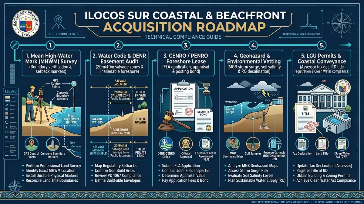
Five-stage practitioner coastal land acquisition and foreshore compliance roadmap for Ilocos Sur detailing boundary surveys, Water Code setbacks, CENRO lease protocols, and environmental vetting.
The DENR Foreshore Lease Agreement (FLA) Permitting Pipeline: Step-by-Step Approval Protocol
For resort owners, boutique hospitality developers, and private estate planners who require exclusive commercial use, boat docking facilities, landscaped beachfront gardens, or temporary cabanas fronting their titled land, securing a Foreshore Lease Agreement (FLA) from the DENR is the only legal pathway. Operating commercial amenities or constructing structures on the foreshore without an approved FLA exposes the owner to immediate administrative fines, demolition of improvements, and eviction.
The Riparian Preferential Right
Under Section 61 of Commonwealth Act No. 141 and DAO 2004-24, the owner of the private land adjoining the foreshore (termed the riparian or littoral owner) is granted a statutory preferential right to apply for and lease the adjacent foreshore. If a third party attempts to apply for a lease over the foreshore directly fronting your titled property, the DENR will notify you as the littoral owner and provide you with a statutory window (typically 60 days) to exercise your preferential right of lease. If you waive this right or fail to apply, only then can the foreshore be leased to another party through public bidding.
The 8-Stage Foreshore Lease Permitting Protocol in Ilocos Sur
Executing an FLA in Ilocos Sur involves a structured multi-agency administrative process coordinated through the local CENRO and PENRO offices:
- Step 1: Establishing Riparian Title Ownership: The applicant must possess an authentic Torrens Title (TCT or OCT) or a certified, uncontested Tax Declaration over the adjoining coastal upland. The title must be accompanied by a certified technical description and cadastral lot plan verified by the Land Management Services of DENR Region 1 in San Fernando, La Union.
- Step 2: Engaging a Licensed Geodetic Engineer for Foreshore Survey: The applicant hires a private geodetic engineer to execute a formal Foreshore Lease Survey. The survey plan maps the exact coordinates of the requested foreshore parcel, the Mean High-Water Mark, the Mean Low-Water Mark, and the adjacent titled boundary. The plan must be submitted to DENR Region 1 for official survey approval and assignment of an FLA survey number.
- Step 3: Filing the Application Docket at CENRO: The application is formally submitted to the appropriate field office:
- CENRO Bantay: For coastal properties in Sinait, Cabugao, San Juan, Magsingal, Santo Domingo, Bantay, San Vicente, Santa Catalina, and Caoayan.
- CENRO Tagudin: For coastal properties in Santa, Narvacan, Santa Maria, San Esteban, Santiago, Candon City, Santa Lucia, Salcedo, and Tagudin.
The filing packet includes the application form, approved survey plan, proof of upland title, Comprehensive Development Plan (outlining proposed improvements, architectural sketches, and environmental management), Barangay Council resolution of no objection, and Municipal Planning and Development Coordinator (MPDC) zoning certification.
- Step 4: Joint Field Investigation and Verification: Land Management Officers from CENRO, accompanied by representatives from the Municipal Engineer Office and MPDC, conduct an on-site ocular inspection. The inspection verifies that the area is genuine foreshore, that it is free from existing legal claims, that it does not infringe on public navigational channels or fish landing areas, and that the proposed development conforms with local coastal resource management plans.
- Step 5: Valuation and Appraisal Committee Determination: Under DAO 2004-24, an official Appraisal Committee determines the fair market value of the foreshore land and the value of the proposed improvements. The appraisal evaluates the commercial potential of the location, proximity to tourism corridors, and local market comparables. The annual lease rental is calculated based on this statutory appraisal.
- Step 6: Public Notice and Publication: Notices of the foreshore lease application must be posted for thirty (30) consecutive days on the bulletin boards of the Provincial Capitol in Vigan City, the Municipal Hall, the Barangay Hall, and on the property itself. For commercial applications exceeding certain monetary thresholds, publication in an official newspaper of general circulation is required to allow any adverse claimants to file formal oppositions.
- Step 7: Securing the Environmental Compliance Certificate (ECC): The applicant must file an environmental impact docket with the Environmental Management Bureau (EMB Region 1). For coastal projects, EMB evaluates liquid waste disposal plans, marine life protection, solid waste handling, and climate resilience. No foreshore lease will be executed without an issued ECC or Certificate of Non-Coverage (CNC).
- Step 8: Payment of Lease Rentals, Cash Guarantee Bond, and Contract Execution: Upon award approval, the applicant pays the first year advance rental fee and posts a mandatory cash performance bond (typically equivalent to twice the annual rental or a percentage of the proposed improvement cost, designed to guarantee faithful compliance with environmental covenants). The formal 25-year Foreshore Lease Agreement is signed by the applicant and the PENRO or DENR Regional Executive Director (RED), and formally registered as an encumbrance on the title record.
Coastal Due Diligence and Geohazard Audits: Soil Salinity, Groundwater Potability, and Storm Surge Vulnerability
Acquiring coastal land without rigorous engineering and environmental testing is one of the costliest mistakes a property investor can make. While a coastal lot may appear picturesque on a sunny morning in February, the West Philippine Sea presents harsh environmental forces during the southwest monsoon (habagat) season. A comprehensive due diligence protocol in Ilocos Sur must evaluate five non-negotiable physical parameters before closing.
1. Storm Surge and Typhoon Wave Action
Ilocos Sur lies directly along the northwestern coastline of Luzon, exposed to severe typhoons crossing the Philippine Area of Responsibility. During high-intensity storms, low atmospheric pressure and strong onshore winds generate storm surges that can push sea water hundreds of meters inland.
Buyers must cross-reference prospective parcels against official geohazard data:
- Mines and Geosciences Bureau (MGB) Geohazard Maps: Review the official 1:10,000 scale coastal hazard maps published by MGB Region 1, identifying whether the parcel is categorized as having High, Moderate, or Low susceptibility to coastal flooding, storm surge inundation, and shoreline retreat.
- PAGASA Storm Surge Vulnerability Profiles: Evaluate historical storm surge inundation levels recorded during past super typhoons in northern Luzon. In low-lying coastal barangays (such as parts of Cabugao, Caoayan, and Santa Cruz), storm surges can exceed 2.0 to 3.5 meters above normal high tide, dictating finished floor elevation (FFE) requirements for any future building design.
2. Historical Coastal Erosion and Shoreline Retreat
Coastal shorelines are dynamic environments subject to continuous sediment transport. In certain areas of Ilocos Sur, wave refraction patterns and offshore currents cause severe sand erosion, while other coves experience steady accretion.
To audit coastal stability:
- Examine historical satellite imagery spanning the last 15 to 20 years (using historical Google Earth Pro and satellite datasets) to visually map whether the vegetative line and sandy beach have retreated inland.
- Conduct local community interviews with long-time barangay residents and local fisherfolk to determine the high-water line reached during severe monsoon seasons. If the shoreline has retreated by 15 meters over the past decade, a 20-meter setback may leave you with zero usable land within twenty years.
3. Groundwater Potability and Saltwater Intrusion
Access to fresh, potable water is the single greatest operational challenge on coastal estates in Ilocos Sur. In rural coastal barangays, public municipal water districts are rarely connected, forcing landowners to rely on private water sources.
The primary threat is saltwater intrusion, where excessive pumping from shallow water tables allows dense seawater to migrate into freshwater coastal aquifers. Before finalizing an acquisition:
- Execute a hydrological soil boring and water sample test from existing neighboring wells.
- Test the water sample at an accredited laboratory for Electrical Conductivity (EC), Total Dissolved Solids (TDS), chloride concentrations, and coliform bacteria. Potable drinking water requires a TDS below 500 parts per million (ppm). In shallow coastal wells, TDS frequently exceeds 1,500 to 3,000 ppm, indicating brackish water unsuitable for plumbing, gardening, or drinking without expensive treatment.
4. Soil Salinity and Marine Structural Concrete Engineering
Building near the ocean requires specialized structural engineering. Standard construction practices used in inland cities will fail catastrophically along the coast within five to ten years due to chloride attack:
- Sand Load-Bearing Capacity: Coastal sandy soils have low bearing capacity and high liquefaction vulnerability during seismic events. Structural designs require deep reinforced concrete footings, grade beams, or micro-piles engineered to withstand soil shifting.
- Sulfate-Resistant Cement: Foundation concrete must utilize Type II or Type V Portland cement or pozzolanic blends to resist sulfate ions present in seawater and saline soils. The water-cement ratio must be strictly kept below 0.40 to minimize concrete porosity.
- Reinforcing Steel Protection: Airborne salt mist penetrates standard concrete, causing conventional carbon steel rebar to oxidize, expand, and spall (crack) the surrounding concrete. Coastal construction mandates a minimum concrete cover of 75 millimeters (3 inches) over all rebar, coupled with epoxy-coated reinforcing bars or galvanized steel framing.
5. Legal Road Right-of-Way (ROW) Easements
Many prime coastal parcels in Ilocos Sur are physically separated from the MacArthur National Highway or provincial roads by agricultural rice fields, coconut groves, or ancestral family estates. Never purchase a coastal property without verifying its legal right-of-way:
- Examine the Transfer Certificate of Title (TCT) for registered road right-of-way annotations on the Memorandum of Encumbrances.
- If access relies on an unregistered dirt track through an adjoining lot, the neighboring owner can legally fence off the road at any time under Article 649 of the Civil Code. Securing a formal, notarized, and registered Deed of Grant of Road Right-of-Way with fair market compensation to the servient estate is an absolute prerequisite to closing.
Infrastructure and Utility Integration for Coastal Estates: Deep Wells, Desalination, Solar, and ISECO Power
Developing a high-end private residence, boutique hospitality villa, or agricultural retreat along the coast requires building self-sufficient utility infrastructure. Municipal utility grids along rural coastlines are often limited, necessitating modern engineering solutions to ensure seamless year-round operations.
1. Fresh Water Engineering: Deep Wells vs Reverse Osmosis Desalination
Securing a reliable freshwater supply requires a dual strategy:
- Deep Confined Aquifer Wells: Rather than utilizing shallow hand pumps (which yield brackish, contaminated water), hire a licensed hydrological drilling contractor to bore down 150 to 300+ feet into deep, confined rock aquifers sealed off from surface seawater infiltration. Securing a Water Permit from the National Water Resources Board (NWRB) is legally required under the Water Code for commercial water extraction.
- Seawater Reverse Osmosis (SWRO) Desalination: For high-end eco-resorts or remote coastal villas, installing a containerized or modular Reverse Osmosis (RO) desalination plant provides total water independence. Modern commercial RO systems can process seawater or brackish well water into pristine drinking water with TDS levels below 100 ppm. Capital costs for a 5,000-liter-per-day system typically range between PHP 450,000 and PHP 750,000, with operational membrane replacement and power consumption costs factored into ongoing maintenance.
- Rainwater Harvesting and Filtration: Incorporating roof catchment systems with multi-stage sediment filters and UV disinfection tanks provides an abundant, mineral-free secondary water supply during the rainy season, reducing wear on RO membranes.
2. Electrical Connectivity and Power Resilience
Electrical service in Ilocos Sur is distributed by the Ilocos Sur Electric Cooperative (ISECO). When purchasing coastal land in rural barangays:
- Distribution Line Audits: Verify the distance from the nearest ISECO secondary distribution line. If the parcel is located 500 meters or more from the grid, the buyer must shoulder the capital cost of installing primary high-voltage line extensions, concrete utility poles, and a dedicated step-down marine-grade transformer (typically costing PHP 250,000 to PHP 600,000 depending on distance and phase requirements).
- Marine Transformer Protection: Salt spray causes rapid corrosion of standard electrical terminals and transformers. Marine-grade oil-immersed transformers with epoxy-coated tanks and stainless steel hardware must be specified.
- Hybrid Solar PV and Battery Storage (BESS): Coastal storms frequently disrupt provincial grid lines. Installing a grid-tied hybrid solar photovoltaic (PV) system with lithium iron phosphate (LiFePO4) battery energy storage guarantees uninterrupted power for essential refrigeration, deep well pumps, and security lighting. Furthermore, coastal Ilocos Sur boasts some of the highest solar irradiance levels in Luzon, delivering exceptional payback periods on solar capital investments.
3. Sanitary Sewage Management under the Philippine Clean Water Act (RA 9275)
Republic Act No. 9275 (The Philippine Clean Water Act of 2004) strictly prohibits the direct discharge of untreated domestic wastewater, sewage, or graywater into marine waters or coastal soil. Violations carry severe administrative penalties, mandatory business closures, and criminal liabilities.
Coastal developments must implement advanced wastewater treatment systems:
- Prohibition of Traditional Open Bottom Septic Tanks: Traditional unsealed cesspools or single-chamber pits allow raw effluent to leach directly into the sandy water table and ocean, contaminating the very beach fronting the estate.
- Sealed Three-Chamber Septic Vaults: Residential coastal villas must install watertight, reinforced concrete three-chamber septic tanks (Digestive Chamber, Leaching Chamber, and Clarification Chamber) adhering strictly to the Revised National Plumbing Code of the Philippines.
- Package Sewage Treatment Plants (Package STP): Commercial resorts, restaurants, or multi-villa estates must install a localized Package STP utilizing moving bed biofilm reactors (MBBR) or activated sludge aeration. The treated effluent must meet DENR Administrative Order No. 2016-08 (Water Quality Guidelines and General Effluent Standards for Class SB marine waters) before being reused for landscape irrigation.
Financial Case Study: Titled Coastal Lot Acquisition vs Foreshore Lease Costs and Development Budget
To illustrate the complete financial arithmetic of acquiring and developing coastal property in Ilocos Sur, we examine a realistic investment model: acquiring a 2,500-square-meter titled beachfront parcel paired with a 1,000-square-meter DENR Foreshore Lease for a boutique eco-resort estate in a prime coastal corridor (such as Santiago Cove, San Esteban, or Cabugao).
This financial breakdown contrasts the capital acquisition costs, transaction taxes, DENR lease obligations, and site engineering infrastructure required to bring a premier coastal estate to development-ready status.
Table 1: Titled Coastal Land Acquisition and Conveyance Outlays (2,500 sqm)
| Cost Item | Basis of Computation | Amount (PHP) |
|---|---|---|
| Gross Land Purchase Price | 2,500 sqm @ PHP 3,500.00 per sqm | 8,750,000.00 |
| Capital Gains Tax (CGT) | 6.0% of Gross Selling Price (statutory seller cost, often factored) | 525,000.00 |
| Documentary Stamp Tax (DST) | 1.5% of Gross Selling Price | 131,250.00 |
| Provincial Transfer Tax | 0.50% of Gross Selling Price (Provincial Ordinance of Ilocos Sur) | 43,750.00 |
| Registration Fee (LRA / RD) | Standard LRA graduated schedule for PHP 8.75M consideration | 44,500.00 |
| Geodetic Relocation Survey | Relocation of 4 boundary corners, MHWM mapping, and mojon setting | 35,000.00 |
| Title Due Diligence & Docket Processing | Certified true copies (RD, Assessor, DAR clearance, legal liaison) | 30,000.00 |
| Total Land Acquisition and Conveyance Outlay | 9,559,500.00 | |
Table 2: DENR Foreshore Lease Agreement Application and Permitting Fees (1,000 sqm)
| Lease Permitting Component | Administrative Basis (DAO 2004-24) | Amount (PHP) |
|---|---|---|
| FLA Application Filing Fee | Official CENRO docket filing and processing fee | 1,500.00 |
| Foreshore Cadastral Survey Plan | Geodetic survey of 1,000 sqm intertidal strip and DENR Region 1 approval | 45,000.00 |
| CENRO / MPDC Ocular Inspection Fee | Statutory inspection fee and technical team transport expenses | 12,000.00 |
| Public Notices and Publication | Posting on LGU bulletin boards and local newspaper legal publication | 25,000.00 |
| Environmental Compliance Certificate (ECC) | EMB Region 1 filing, Initial Environmental Examination (IEE), processing | 75,000.00 |
| First Year Advance Annual Rental | 3% of appraised land value (1,000 sqm @ PHP 1,200 appraised value = PHP 36,000/yr) | 36,000.00 |
| Mandatory Cash Guarantee Bond | Statutory performance bond (refundable upon compliance, twice annual rental) | 72,000.00 |
| Total Foreshore Lease Permitting and Initial Reserve | 266,500.00 | |
Table 3: Coastal Site Engineering and Utility Infrastructure Capital Outlay
| Infrastructure Package | Engineering Specifications | Amount (PHP) |
|---|---|---|
| Hydrological Deep Well Drilling | 200-foot confined aquifer bore, stainless steel casing, submersible pump, NWRB permit | 380,000.00 |
| Seawater/Brackish Reverse Osmosis Unit | Modular 5,000 LPD RO plant, sand pre-filtration, anti-scalant dosing, UV sterilizer | 550,000.00 |
| ISECO Power Extension & Transformer | 3 concrete poles, high-voltage line drop, 50 kVA marine-grade step-down transformer | 420,000.00 |
| Hybrid Solar PV & Storage (BESS) | 10 kW Tier-1 solar array, 15 kWh LiFePO4 battery storage, marine-coated racking | 680,000.00 |
| Engineered 3-Chamber Septic System | Watertight reinforced concrete vault, anaerobic filter, effluent pumping chamber | 240,000.00 |
| Access Road Stabilization & Drainage | 150-meter stabilized aggregate driveway, drainage swales, and culverts | 350,000.00 |
| Setback Fencing & Dune Revegetation | Perimeter fencing set back 20m from MHWM, vetiver grass and beach morning glory planting | 180,000.00 |
| Total Site Engineering & Utility Infrastructure Outlay | 2,800,000.00 | |
Table 4: Consolidated Project Capital Budget and Economic Summary
| Development Phase | Budget Allocation (PHP) | Percentage of Total |
|---|---|---|
| Phase 1: Titled Coastal Land Acquisition and Conveyance Taxes | 9,559,500.00 | 75.7% |
| Phase 2: DENR Foreshore Lease Application, Appraisal & Guarantee Bond | 266,500.00 | 2.1% |
| Phase 3: Site Infrastructure, Off-Grid Utilities & Environmental Systems | 2,800,000.00 | 22.2% |
| Consolidated Development-Ready Capital Investment | 12,626,000.00 | 100.0% |
Strategic Economic Takeaway: Notice that securing an approved 25-year DENR Foreshore Lease over 1,000 square meters of prime beachfront requires an initial capital outlay of only PHP 266,500.00 (representing just 2.1% of the total investment), with an annual recurring lease rental of approximately PHP 36,000.00. This delivers complete legal certainty, exclusive recreational utilization, and unassailable protection against competitor encroachment at a fraction of the cost of titled land. Attempting to develop without an FLA risks catastrophic regulatory demolition of your beachfront amenities.
Master Ilocos Sur Coastal and Beachfront Property Due Diligence Matrix Table
The following master reference matrix synthesizes the complex statutory, tenurial, and physical boundaries governing coastal land across Ilocos Sur. Use this matrix to audit property documents, evaluate building envelopes, and isolate compliance risks before executing binding legal agreements.
| Coastal Zone Classification | Governing Statutory Authority | Legal Ownership / Tenurial Instrument | Permitted Structures & Activities | Prohibited Uses & Encroachments | Primary Compliance Risks & Audit Protocol |
|---|---|---|---|---|---|
| Titled Coastal Upland | Land Registration Authority (LRA), Register of Deeds, Municipal Assessor & MPDC | Fee Simple Private Ownership under Torrens Title (OCT / TCT) | Permanent residential villas, boutique hotels, commercial buildings, swimming pools, deep wells (NWRB-approved) | Building beyond approved cadastral boundary markers; encroaching into the 20-meter statutory salvage easement | Overlap with inalienable public domain; fraudulent paper titles; lack of registered road right-of-way to national highway |
| Salvage Zone / Environmental Easement | DENR, DPWH, Local Government Unit (LGU), Philippine Coast Guard | Statutory Public Easement under Article 51 of Presidential Decree No. 1067 | Recreation, navigation, public salvage, temporary light furniture, permeable footpaths, landscaping, dune grass | Permanent concrete foundations, perimeter security walls, gates, commercial restaurants, septic tanks, sewage discharge | Summary demolition by DPWH / LGU without compensation; civil damages and criminal prosecution under the Water Code |
| Foreshore Land (Intertidal Strip) | DENR (CENRO Bantay / Tagudin, PENRO Ilocos Sur), EMB Region 1 | Foreshore Lease Agreement (FLA) under CA 141 and DENR DAO 2004-24 (25-year lease) | Removable open-sided cabanas, timber boardwalks, floating boat docks, non-permanent recreational beach amenities | Unauthorized commercial exploitation, concrete seawalls without engineering approval, illegal sand quarrying, sub-leasing to third parties | Operating without an approved FLA; denial of lease renewal; forfeiture of cash bond; cancellation of ECC for marine degradation |
| Marine Submerged Waters | Philippine Coast Guard, BFAR, Maritime Police, Municipal Fishery Council | Inalienable Sovereign State Waters (Regalian Doctrine / UNCLOS) | Maritime navigation, municipal artisanal fishing, approved marine protected sanctuaries, recreational water sports | Unauthorized land reclamation, dredging, artificial island creation, mooring permanent marine barges without PCG permits | Confiscation of maritime vessels; criminal charges under the Philippine Fisheries Code (RA 8550 as amended by RA 10654) |
Frequently Asked Questions (FAQ) About Coastal and Beachfront Property in Ilocos Sur
1. Can a private individual own the beach in front of their coastal property in the Philippines?
No. Under the Regalian Doctrine, Commonwealth Act No. 141 (The Public Land Act), and the 1987 Philippine Constitution, all beaches, shores, and foreshores belong to the public domain and are inalienable. A private Torrens title can only cover alienable and disposable upland land situated inland from the Mean High-Water Mark. Even if an older survey or deed includes the sand down to the water, that portion is legally void ab initio. To utilize the beach fronting your titled property for commercial resort amenities, boardwalks, or private cabanas, you must apply for a 25-year Foreshore Lease Agreement (FLA) from the DENR.
2. What is the mandatory setback easement when building on beachfront land in Ilocos Sur?
Under Article 51 of Presidential Decree No. 1067 (The Water Code of the Philippines), the mandatory setback easement along the shores of the sea is 20 meters in rural and agricultural areas (which encompasses nearly all coastal municipalities in Ilocos Sur, including Cabugao, San Esteban, Santiago, and Santa Maria). In declared urban zones, the easement is 3 meters, while in forest reserves, it is 40 meters. This easement is measured landward from the Mean High-Water Mark. You cannot erect permanent residential buildings, commercial structures, concrete perimeter fences, or septic tanks inside this 20-meter strip.
3. What is a Foreshore Lease Agreement (FLA) and who is eligible to apply for one?
A Foreshore Lease Agreement (FLA) is a formal contract executed with the Department of Environment and Natural Resources (DENR) granting exclusive commercial, residential, or recreational leasehold rights over a defined foreshore area for a period of twenty-five (25) years, renewable for another twenty-five (25) years. Under Section 61 of CA 141 and DAO 2004-24, the owner of the adjoining titled coastal upland (the riparian or littoral owner) has the statutory preferential right to lease the adjacent foreshore. Filipino citizens and registered Philippine corporations with at least 60% Filipino capital ownership are eligible to apply through the local CENRO office.
4. What happens if a beachfront property title includes land below the high-tide mark?
If a private title encompasses land below the Mean High-Water Mark due to historical surveying errors, inaccurate cadastral mapping, or coastal erosion, the portion submerged or situated below the high-water mark is legally null and void. The Supreme Court has repeatedly affirmed that the Torrens system does not protect titles issued over public domain foreshores. In such cases, the Office of the Solicitor General (OSG) can initiate reversion proceedings to cancel the coastal portion of the title. Buyers should engage a licensed geodetic engineer to conduct a boundary relocation survey and negotiate purchase pricing strictly based on the net dry land situated above the high-tide line.
5. How do buyers test for groundwater potability and avoid saltwater intrusion on coastal lots?
Before closing on a coastal parcel, buyers should hire a licensed well-drilling contractor to drill a test borehole and extract water samples. The samples must be analyzed at an accredited laboratory for Total Dissolved Solids (TDS), Electrical Conductivity (EC), and chloride levels. Potable fresh water must maintain a TDS below 500 ppm. If the test reveals brackish water (TDS between 1,000 and 3,000+ ppm), the buyer must budget for a deep-aquifer well (150 to 300+ feet deep) or install a modular seawater Reverse Osmosis (RO) desalination system. Furthermore, water extraction for commercial hospitality operations requires an official Water Permit from the National Water Resources Board (NWRB).
6. Can foreign nationals buy coastal land or secure a foreshore lease in Ilocos Sur?
Under Article XII of the 1987 Philippine Constitution, foreign nationals cannot directly own private land in the Philippines, including coastal and beachfront properties. Foreigners married to Filipino citizens cannot have their names on the land title (though they may be acknowledged as spouses). However, foreign individuals and international resort developers can legally participate through three compliant legal structures: (1) Long-term leasing of private titled upland for up to 50 years (renewable for 25 years under the Investors Lease Act, RA 7652); (2) Acquiring up to 40% equity in a Philippine corporation that holds titled coastal land and foreshore leases; or (3) Purchasing condominium units or condotel villas where foreign ownership does not exceed the 40% statutory threshold under Republic Act No. 4726.
Professional Coastal Real Estate Advisory and Acquisition Services in Ilocos Sur
Acquiring beachfront property is among the most rewarding real estate investments in Northern Luzon, combining long-term capital appreciation with lifestyle prestige. However, the intersection of maritime environmental laws, Water Code setbacks, DENR foreshore leases, and coastal geohazards leaves no room for guesswork.
Headquartered directly in Ilocos Sur and founded in 2023, LandMaster Realty provides licensed, full-spectrum advisory, geodetic verification, and acquisition representation across both coastal acreage and master-planned residential communities such as Tierra Vista Subdivision. Led by Licensed Real Estate Broker and Appraiser Algero Favis, our practice manages the complete coastal conveyance lifecycle:
- Forensic Title and Boundary Verification: Verifying Torrens titles at the Register of Deeds, auditing Assessor tax declarations, and securing official certified cadastral plans from DENR Region 1.
- Geodetic Relocation and High-Tide Surveys: Deploying licensed geodetic engineers to physically establish the Mean High-Water Mark (MHWM), audit Water Code 20-meter salvage setbacks, and install permanent concrete boundary monuments (mojones).
- CENRO and PENRO Lease Permitting: Structuring and processing Foreshore Lease Agreements (FLA) through CENRO Bantay and CENRO Tagudin, coordinating joint field investigations, and liaising with the Environmental Management Bureau for ECC approvals.
- Off-Grid Infrastructure and Engineering Consultation: Advising clients on reverse osmosis desalination, deep well permits, ISECO grid extensions, and resilient coastal structural specifications.